
Where is Manipur, Capital of Manipur, Population of Manipur
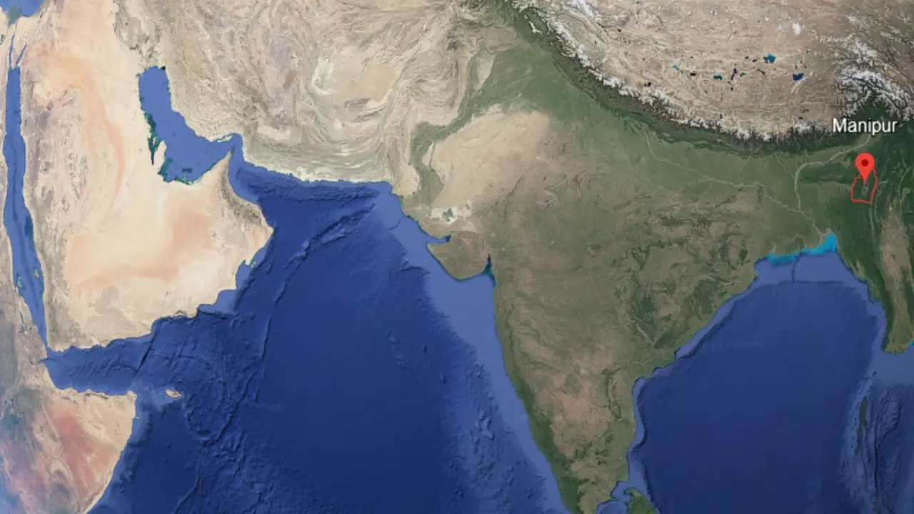
Where is Manipur: Manipur is a state located in the northeastern part of India. Manipur touches Nagaland in the north, Mizoram in the south, Assam in the west, and the country Myanmar in the east. Manipur became a state of India in the year 1972. The capital city and state head office of Manipur is Imphal. In 2025, the population of Manipur is about 32.8 lakh.
Manipur has 16 districts and the total area of all districts is around 22,327 square kilometers. People in Manipur mainly speak Meitei (official language), and also other languages like Thadou and Tangkhul. Manipur is known for its natural beauty, hills, lakes, and rich culture. Where is Manipur, Capital of Manipur, Population of Manipur.
| Manipur country name | India |
| Manipur state name | Manipur |
| Capital of Manipur | Imphal |
| Manipur government office | Imphal |
| Manipur area in sq km | Approx. 22,327 sq km (includes all districts, cities, and villages) |
| Main language of Manipur | Meitei (Manipuri), English, Hindi |
| Manipur top 10 cities (By development) | Imphal, Thoubal, Bishnupur, Churachandpur, Kakching, Ukhrul, Senapati, Tamenglong, Moreh, Moirang |
| Largest district in Manipur by population | Imphal West |
| Manipur population 2025 | Around 3.28 million (32.8 lakhs) |
| Manipur chief minister name | N. Biren Singh (as of June 2025) |
| Total districts in Manipur | 16 |
| Governor of Manipur | Anusuiya Uikey |
| Manipur official website | manipur.gov.in |
Which are the neighboring states of Manipur
Manipur state touches Nagaland state on the north side with a boundary of about 242 km, Assam state on the west side with a boundary of about 204 km, and Mizoram state on the south-west side with a boundary of about 130 km. Along with Indian states, Manipur state also has an international border with Myanmar country on the east side, and this boundary is about 398 km long. The total area of Manipur state is nearly 22,327 square kilometres, where the valley region covers about 2,238 square kilometres and the hilly region covers about 20,089 square kilometres.
How many districts are there in Manipur
Manipur has a total of 16 districts. The largest district of Manipur state by area is Churachandpur district. Churachandpur is the largest in area because it covers extensive hilly regions and forests, making it spread over more land than any other district. The largest district of Manipur state by population is Imphal West district. Imphal West district has the highest population because it is the economic, administrative, and urban hub of Manipur state, attracting more people to live and work there. The smallest district of Manipur state by area is Imphal East district, which occupies less land. The smallest district of Manipur state by population is Kamjong district, which has fewer people due to its rural terrain.
| No. | District name | Headquarter city |
|---|---|---|
| 1 | Bishnupur | Bishnupur |
| 2 | Chandel | Chandel |
| 3 | Churachandpur | Churachandpur |
| 4 | Imphal East | Porompat |
| 5 | Imphal West | Lamphelpat |
| 6 | Jiribam | Jiribam |
| 7 | Kakching | Kakching |
| 8 | Kamjong | Kamjong |
| 9 | Kangpokpi | Kangpokpi |
| 10 | Noney | Noney |
| 11 | Pherzawl | Pherzawl |
| 12 | Senapati | Senapati |
| 13 | Tamenglong | Tamenglong |
| 14 | Tengnoupal | Tengnoupal |
| 15 | Thoubal | Thoubal |
| 16 | Ukhrul | Ukhrul |
What is the capital of Manipur
Imphal is the capital of Manipur. It has been the center of power since the time of the Manipuri kings, who ruled from Kangla Fort. When Manipur joined India in 1949, Imphal continued to be the capital, and later, in 1972, when Manipur became a full-fledged state, Imphal remained its capital city. Today, Imphal is the main place for the government’s work. Important offices such as the Manipur Legislative Assembly, the State Secretariat, and the Manipur High Court are located here.
Who is the Governor of Manipur
Ajay Kumar Bhalla is the 19th Governor of Manipur, having taken office on January 3, 2025, following the death of Governor La. Ganesan. Prior to this, Bhalla served as the Union Home Secretary of India from August 23, 2019, to August 22, 2024. He is a 1984-batch IAS officer from the Assam-Meghalaya cadre and hails from Jalandhar, Punjab. Before becoming Home Secretary, Bhalla held key positions such as Secretary in the Ministry of Power and Director General of Foreign Trade. He was also Joint Secretary in the Ministry of Coal and Director in the Department of Shipping .
Who is the chief minister of Manipur
Nongthombam Biren Singh served as the Chief Minister of Manipur from March 15, 2017, until February 13, 2025. He was the first person from the Bharatiya Janata Party (BJP) to hold this position. Before him, Okram Ibobi Singh of the Indian National Congress was the Chief Minister. Biren Singh resigned amid ongoing ethnic violence between the Meitei and Kuki communities, which led to over 250 deaths and the displacement of thousands.
Manipur all chief ministers list
| Manipur Chief Minister Name | Working Period |
|---|---|
| Mairembam Koireng Singh | January 21, 1963 – January 11, 1967 |
| Mairembam Koireng Singh | March 20, 1967 – October 4, 1967 |
| Longjam Thambou Singh | October 4, 1967 – October 16, 1967 |
| Mairembam Koireng Singh | October 16, 1967 – January 16, 1972 |
| Mohammed Alimuddin | March 23, 1972 – March 27, 1973 |
| President’s Rule | March 27, 1973 – March 4, 1974 |
| Mohammed Alimuddin | March 4, 1974 – July 9, 1974 |
| Yangmaso Shaiza | July 10, 1974 – December 5, 1974 |
| President’s Rule | December 5, 1974 – December 20, 1974 |
| Yangmaso Shaiza | December 20, 1974 – May 16, 1977 |
| Raj Kumar Dorendra Singh | May 16, 1977 – November 28, 1979 |
| President’s Rule | November 28, 1979 – January 13, 1980 |
| Raj Kumar Dorendra Singh | January 14, 1980 – November 27, 1980 |
| Maibam Tombi Singh | November 28, 1980 – April 27, 1981 |
| Raj Kumar Jaichandra Singh | April 27, 1981 – April 27, 1984 |
| Raj Kumar Dorendra Singh | April 28, 1984 – March 8, 1985 |
| Rishang Keishing | March 9, 1985 – February 19, 1988 |
| President’s Rule | February 19, 1988 – February 27, 1988 |
| Rishang Keishing | February 28, 1988 – December 7, 1990 |
| Raj Kumar Dorendra Singh | December 8, 1990 – January 6, 1992 |
| President’s Rule | January 7, 1992 – April 7, 1992 |
| Rishang Keishing | April 8, 1992 – December 14, 1994 |
| Raj Kumar Dorendra Singh | December 14, 1994 – December 15, 1997 |
| Wahengbam Nipamacha Singh | December 16, 1997 – February 14, 2001 |
| Radhabinod Koijam | February 15, 2001 – June 1, 2001 |
| President’s Rule | June 2, 2001 – June 6, 2001 |
| Okram Ibobi Singh | June 7, 2001 – March 15, 2017 |
| Nongthombam Biren Singh | March 15, 2017 – February 9, 2025 |
| President’s Rule | February 13, 2025 – Present |
FAQs
Manipur is a state in the northeastern part of India, and the capital city of Manipur state is Imphal.
The population of Manipur state in 2025 is around 3.28 million people
The total area of Manipur state is 22,327 square kilometres.
The total number of districts in Manipur state is 16.