
Where is Azamgarh district, Azamgarh area in sq km, Azamgarh population 2025
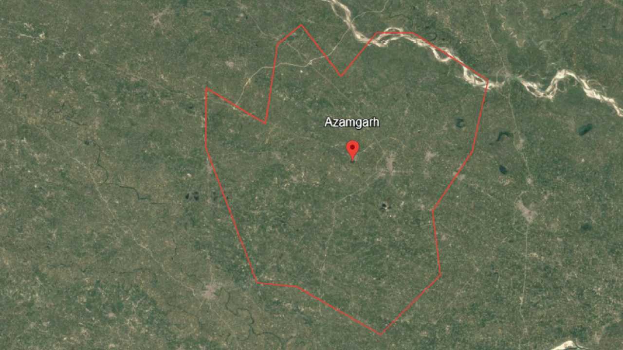
Where is Azamgarh district: Azamgarh district is a district in the eastern part of Uttar Pradesh, a state in India. Azamgarh district is managed from Azamgarh city, which is the district headquarter. Azamgarh district is spread over about 4,054 square kilometers. In the year 2025, the population of Azamgarh district is estimated to be around 51 lakh people. The RTO code of Azamgarh district is UP-50, which is used for vehicle registration.
Azamgarh district is surrounded by Mau, Jaunpur, Gorakhpur, Ghazipur, Ambedkar Nagar, and Sultanpur districts. The main languages spoken in Azamgarh district are Hindi, Bhojpuri, and Urdu. Azamgarh district is well connected to other cities by roads and railways.
| Azamgarh state name | Uttar Pradesh |
| Azamgarh district Headquarter | Azamgarh City |
| Azamgarh Pin Code number (City) | 276001 |
| Azamgarh RTO code | UP 50 |
| Azamgarh area in sq km | Around 4,054 sq km |
| Main local Languages | Hindi, Urdu, Bhojpuri |
| Azamgarh population 2025 | Around 5.49 million (54.96 lakhs) |
| Nearest Airport to Azamgarh | Azamgarh Airport (Dumat), also Varanasi Airport (Lal Bahadur Shastri) |
| Major Cities in Azamgarh District | Azamgarh, Mubarakpur, Mehnagar, Jahanaganj, Phoolpur |
| All Tehsils & Sub-Tehsils | Tehsils: Azamgarh, Mehnagar, Nizamabad, Phulpur, Sagri, Lalganj, Burhanpur, Martinganj |
| Azamgarh DM name | Shri Ravindra Kumar (IAS) |
| Azamgarh DM office address | Collectorate Bhawan, Civil Lines, Azamgarh, Uttar Pradesh, 276001 |
| Azamgarh district website | azamgarh.nic.in |
Which are the neighbouring districts of Azamgarh, neighbouring cities of Azamgarh
Azamgarh district is surrounded by several nearby districts. To the north, Mau district touches Azamgarh for about 58 kilometers. On the northeast side, Ghazipur district shares a border of around 35 kilometers. Ballia district lies to the east and is connected for 25 kilometers. Jaunpur district is on the south side, touching Azamgarh for about 70 kilometers.
Ambedkar Nagar is on the southwest and shares around 60 kilometers of border. Sultanpur lies to the west and connects for 30 kilometers. On the northwest side, Gorakhpur district touches Azamgarh for about 22 kilometers. All these districts are also in Uttar Pradesh.
Which is the main railway station of Azamgarh
Azamgarh district in Uttar Pradesh does not have an operational airport. The nearest major airport to Azamgarh is Lal Bahadur Shastri International Airport in Varanasi, situated about 95 km away.
Azamgarh airport name
Azamgarh Railway Station, located in Musapur, Palhani, Azamgarh, Uttar Pradesh, is the main railway station of Azamgarh district. Azamgarh Railway Station was built in 1896 during British rule, making Azamgarh Railway Station more than 125 years old. Azamgarh Railway Station has four platforms and is part of the North Eastern Railway zone under the Varanasi division. Azamgarh district has a total of 11 railway stations, including Azamgarh Railway Station.
What is the pin code of Azamgarh
Azamgarh Pin code (A-F)
| Post offices | PIN Code | District | SO./B.O./H.O |
|---|---|---|---|
| Abusaidpur | 276205 | Azamgarh | B.O. |
| Ajagara Masharki | 276122 | Azamgarh | B.O. |
| Ajaji Dewara Karkhia | 276122 | Azamgarh | B.O. |
| Ajamat Garh Estate | 276124 | Azamgarh | S.O. |
| Ajampur | 276125 | Azamgarh | B.O. |
| Aira Bujurg | 276126 | Azamgarh | B.O. |
| Amarhar | 276403 | Azamgarh | B.O. |
| Amari | 276142 | Azamgarh | B.O. |
| Ambari | 223222 | Azamgarh | S.O. |
| Ambarpur | 223227 | Azamgarh | B.O. |
| Amilo | 276401 | Azamgarh | S.O. |
| Amuwari | 276138 | Azamgarh | B.O. |
| Anjam Shhid | 276125 | Azamgarh | B.O. |
| Araji Amani | 276139 | Azamgarh | B.O. |
| Ashona | 276406 | Azamgarh | B.O. |
| Ashwania | 276301 | Azamgarh | B.O. |
| Ataraith | 276142 | Azamgarh | B.O. |
| Ataraulia | 223223 | Azamgarh | S.O. |
| Azamgarh City | 276001 | Azamgarh | S.O. |
| Azamgarh | 276001 | Azamgarh | H.O. |
| Azamgarh Kachhehari | 276001 | Azamgarh | S.O. |
| Azamgarh R.S | 276001 | Azamgarh | S.O. |
| Babu Ki Basti | 276305 | Azamgarh | B.O. |
| Babu Ki Khajuri | 276204 | Azamgarh | B.O. |
| Bachhawal | 276204 | Azamgarh | B.O. |
| Badagaon | 223227 | Azamgarh | B.O. |
| Badaharia | 223227 | Azamgarh | B.O. |
| Badasara Aima | 276141 | Azamgarh | B.O. |
| Badasara Khalsa | 276141 | Azamgarh | B.O. |
| Badaura | 276128 | Azamgarh | B.O. |
| Badaya | 223223 | Azamgarh | B.O. |
| Baddo Pur | 276001 | Azamgarh | B.O. |
| Bahadur Pur | 276201 | Azamgarh | B.O. |
| Bahauddinpur. | 276288 | Azamgarh | B.O. |
| Baijabari | 276122 | Azamgarh | B.O. |
| Bairampur | 276206 | Azamgarh | B.O. |
| Bakhara | 223226 | Azamgarh | B.O. |
| Baksh Pur | 276303 | Azamgarh | B.O. |
| Balaipur | 276143 | Azamgarh | B.O. |
| Bamhaur | 276406 | Azamgarh | B.O. |
| Ban Kat Jagdeesh | 276142 | Azamgarh | B.O. |
| Banbirpur | 276304 | Azamgarh | B.O. |
| Bangaon | 276123 | Azamgarh | B.O. |
| Bankat | 276125 | Azamgarh | S.O. |
| Bankatia | 276136 | Azamgarh | B.O. |
| Bansgaon | 223223 | Azamgarh | B.O. |
| Bansgaon | 276126 | Azamgarh | S.O. |
| Barahalaganj | 276129 | Azamgarh | B.O. |
| Baraipur | 223221 | Azamgarh | B.O. |
| Barauna | 276301 | Azamgarh | B.O. |
| Bardah | 276301 | Azamgarh | S.O. |
| Bardiha | 276136 | Azamgarh | B.O. |
| Bargahan | 276301 | Azamgarh | B.O. |
| Barikhas | 276206 | Azamgarh | B.O. |
| Barohi Fetahpur | 276121 | Azamgarh | B.O. |
| Basahia | 223223 | Azamgarh | B.O. |
| Base Pur Dandava | 223223 | Azamgarh | B.O. |
| Basgit | 276001 | Azamgarh | B.O. |
| Bazar Gosain | 276127 | Azamgarh | S.O. |
| Beenapara | 276305 | Azamgarh | B.O. |
| Bela Kasaila | 276306 | Azamgarh | B.O. |
| Bela Klichpur | 276203 | Azamgarh | B.O. |
| Bela Sultanpur | 275307 | Azamgarh | B.O. |
| Belaon | 276302 | Azamgarh | B.O. |
| Belauli | 221602 | Azamgarh | B.O. |
| Benupur | 276204 | Azamgarh | B.O. |
| Beohara | 276202 | Azamgarh | B.O. |
| Berama | 276138 | Azamgarh | B.O. |
| Bhadaon | 223224 | Azamgarh | B.O. |
| Bhagat Pur | 223223 | Azamgarh | B.O. |
| Bhagwat | 276129 | Azamgarh | B.O. |
| Bhaisha | 276139 | Azamgarh | B.O. |
| Bhangaha | 276128 | Azamgarh | B.O. |
| Bhani Pur | 276288 | Azamgarh | B.O. |
| Bharathipur | 276123 | Azamgarh | B.O. |
| Bharauli | 276142 | Azamgarh | B.O. |
| Bhavar Nath | 276001 | Azamgarh | B.O. |
| Bhawarpur | 276123 | Azamgarh | B.O. |
| Bhedaura | 276141 | Azamgarh | B.O. |
| Bheera | 276301 | Azamgarh | B.O. |
| Bhilampur Chhapra | 276142 | Azamgarh | B.O. |
| Bhimal Patti | 223221 | Azamgarh | B.O. |
| Bhimbar | 276121 | Azamgarh | B.O. |
| Bhopalpur | 276202 | Azamgarh | B.O. |
| Bhormau | 276304 | Azamgarh | B.O. |
| Bhuidharpur | 276208 | Azamgarh | B.O. |
| Bhujahi | 276131 | Azamgarh | B.O. |
| Bhuvana Bujurga | 276405 | Azamgarh | B.O. |
| Bibipur | 276123 | Azamgarh | B.O. |
| Bibipur | 276135 | Azamgarh | B.O. |
| Bilari | 223221 | Azamgarh | B.O. |
| Bilaria Ganj | 276121 | Azamgarh | S.O. |
| Bind Mathia | 276404 | Azamgarh | B.O. |
| Bindawal | 276121 | Azamgarh | B.O. |
| Bindra Bazar | 276205 | Azamgarh | B.O. |
| Bisham | 276205 | Azamgarh | B.O. |
| Bisunpura | 276405 | Azamgarh | B.O. |
| Bithuwa | 276202 | Azamgarh | B.O. |
| Bunda | 223226 | Azamgarh | B.O. |
| Buxpur Mejawa | 276304 | Azamgarh | B.O. |
| Chak Inami | 276001 | Azamgarh | B.O. |
| Chaklal Chand | 276138 | Azamgarh | B.O. |
| Chan Patti | 276122 | Azamgarh | B.O. |
| Chandabhari | 276206 | Azamgarh | B.O. |
| Chandai | 276207 | Azamgarh | B.O. |
| Chandesar | 276128 | Azamgarh | S.O. |
| Chewar Pachhim | 276201 | Azamgarh | B.O. |
| Chewata | 276141 | Azamgarh | B.O. |
| Chhaon | 276302 | Azamgarh | B.O. |
| Chhapra Sultanpur | 276124 | Azamgarh | B.O. |
| Chhattarpur Khushahal | 276125 | Azamgarh | B.O. |
| Chhihi | 276121 | Azamgarh | B.O. |
| Chhitauna | 223221 | Azamgarh | B.O. |
| Chhittepur | 223226 | Azamgarh | B.O. |
| Chirkihit | 276202 | Azamgarh | B.O. |
| Chitara Mahamud Pur | 223224 | Azamgarh | B.O. |
| Dama | 276204 | Azamgarh | B.O. |
| Dandwal | 276203 | Azamgarh | B.O. |
| Daniyalpur | 223221 | Azamgarh | B.O. |
| Daulatabad | 276129 | Azamgarh | B.O. |
| Dayalpur | 276302 | Azamgarh | B.O. |
| Deeha | 276128 | Azamgarh | B.O. |
| Deora Patti | 223223 | Azamgarh | B.O. |
| Dev Gaon | 276201 | Azamgarh | S.O. |
| Dewait | 276204 | Azamgarh | B.O. |
| Dewal Ashram | 276405 | Azamgarh | B.O. |
| Dewara Jadid | 276137 | Azamgarh | B.O. |
| Dewara Jadidi | 276139 | Azamgarh | B.O. |
| Dewara Khas Raja | 276122 | Azamgarh | B.O. |
| Dhamsinga | 281401 | Azamgarh | B.O. |
| Dharmdaspur Newada | 276304 | Azamgarh | B.O. |
| Dharwara | 276131 | Azamgarh | B.O. |
| Didarganj | 223224 | Azamgarh | S.O. |
| Dighwania Kaji | 276136 | Azamgarh | B.O. |
| Dighwania Majhuwa | 276124 | Azamgarh | B.O. |
| Diriapur Newada | 276203 | Azamgarh | B.O. |
| Dubara | 276301 | Azamgarh | B.O. |
| Durbasa | 276304 | Azamgarh | B.O. |
| Edilpur | 223221 | Azamgarh | B.O. |
| Emalipur | 276121 | Azamgarh | B.O. |
| Esmail Pir | 276122 | Azamgarh | B.O. |
| Faridpur | 223225 | Azamgarh | B.O. |
| Fariha | 223227 | Azamgarh | B.O. |
| Firuddin Pur | 223227 | Azamgarh | B.O. |
| Fulesh | 223224 | Azamgarh | B.O. |
Azamgarh Pin code (G-M)
| Post offices | PIN Code | District | SO./B.O./H.O |
|---|---|---|---|
| Gaddopur | 276121 | Azamgarh | B.O. |
| Gahaji | 223221 | Azamgarh | B.O. |
| Gajendra Patti Bhidaura | 223223 | Azamgarh | B.O. |
| Galib Pur | 276288 | Azamgarh | B.O. |
| Gambhir Ban | 276128 | Azamgarh | B.O. |
| Gambhirpur | 276302 | Azamgarh | S.O. |
| Gandhuai | 223227 | Azamgarh | B.O. |
| Garerua | 276136 | Azamgarh | B.O. |
| Gaura | 276204 | Azamgarh | B.O. |
| Gaura | 276142 | Azamgarh | B.O. |
| Gauri | 223221 | Azamgarh | B.O. |
| Gauri Narayanpur | 276135 | Azamgarh | B.O. |
| Godhana | 223222 | Azamgarh | B.O. |
| Gomadih | 276202 | Azamgarh | B.O. |
| Gonghat | 276306 | Azamgarh | B.O. |
| Gopal Pur Sadar | 276001 | Azamgarh | B.O. |
| Gopalpur | 276204 | Azamgarh | B.O. |
| Gopalpur Sethuli | 276201 | Azamgarh | B.O. |
| Govind Pur | 223223 | Azamgarh | B.O. |
| Gujar Par | 276404 | Azamgarh | B.O. |
| Guwai | 223224 | Azamgarh | B.O. |
| Hafiz Pur | 276001 | Azamgarh | B.O. |
| Haidarabad | 276139 | Azamgarh | B.O. |
| Haji Pur | 276122 | Azamgarh | B.O. |
| Haraia | 276127 | Azamgarh | B.O. |
| Haraura | 276126 | Azamgarh | B.O. |
| Hardaspur | 276204 | Azamgarh | B.O. |
| Harkhpura Khas | 276139 | Azamgarh | B.O. |
| Harra Ki Chungi | 276001 | Azamgarh | B.O. |
| Hira Patti | 276001 | Azamgarh | B.O. |
| Hubbi Ganj | 223224 | Azamgarh | B.O. |
| Huse Pur | 276137 | Azamgarh | B.O. |
| Irani | 276303 | Azamgarh | B.O. |
| Ishapur | 223226 | Azamgarh | B.O. |
| Itaura Dori Pur | 275305 | Azamgarh | B.O. |
| Jagdishpur | 276304 | Azamgarh | B.O. |
| Jagdishpur | 276124 | Azamgarh | B.O. |
| Jahana Ganj | 276131 | Azamgarh | S.O. |
| Jairajpur | 276121 | Azamgarh | B.O. |
| Jaitipur | 276202 | Azamgarh | B.O. |
| Jamal Pur | 276001 | Azamgarh | B.O. |
| Jamalpur | 276205 | Azamgarh | B.O. |
| Jamdih | 275304 | Azamgarh | B.O. |
| Jameel Pur | 276139 | Azamgarh | B.O. |
| Jameen Bilari | 276124 | Azamgarh | B.O. |
| Jameen Harkhori | 276138 | Azamgarh | B.O. |
| Jameen Rasulpur | 276127 | Azamgarh | B.O. |
| Jamuawan | 276303 | Azamgarh | B.O. |
| Jeoli | 276301 | Azamgarh | B.O. |
| Jigar Sandi | 276129 | Azamgarh | B.O. |
| Jiyanpur | 276140 | Azamgarh | S.O. |
| Jokhara | 276136 | Azamgarh | B.O. |
| Jolhapur | 276135 | Azamgarh | B.O. |
| Jurarampur | 276139 | Azamgarh | B.O. |
| Kabiruddin Pur | 276142 | Azamgarh | B.O. |
| Kakarahatta | 276125 | Azamgarh | B.O. |
| Kakarahi | 276142 | Azamgarh | B.O. |
| Kalafatpur | 276143 | Azamgarh | B.O. |
| Kalanderpur | 276302 | Azamgarh | B.O. |
| Kalicha Bad | 276201 | Azamgarh | B.O. |
| Kamahariya | 276123 | Azamgarh | B.O. |
| Kammar Pur | 276303 | Azamgarh | B.O. |
| Kanaila | 276128 | Azamgarh | B.O. |
| Kandhara Pur | 276135 | Azamgarh | S.O. |
| Kanjahit | 276201 | Azamgarh | B.O. |
| Karauti | 276204 | Azamgarh | B.O. |
| Karisath | 276131 | Azamgarh | B.O. |
| Kariya Gopal Pur | 276201 | Azamgarh | B.O. |
| Karkhia Rutam Sarai | 276122 | Azamgarh | B.O. |
| Karsara | 276202 | Azamgarh | B.O. |
| Karui | 223224 | Azamgarh | B.O. |
| Katauli Kala | 276202 | Azamgarh | B.O. |
| Kaudia | 276141 | Azamgarh | B.O. |
| Kaura Gahani | 223224 | Azamgarh | B.O. |
| Kekai Hindola | 276402 | Azamgarh | B.O. |
| Kerama | 276406 | Azamgarh | B.O. |
| Keshav Pur | 276142 | Azamgarh | B.O. |
| Khairuddinpur | 276288 | Azamgarh | B.O. |
| Khajuri | 223221 | Azamgarh | B.O. |
| Khaliasemari | 276206 | Azamgarh | B.O. |
| Khalispur | 276138 | Azamgarh | B.O. |
| Khan Pur Bhagatpatti | 276139 | Azamgarh | B.O. |
| Khandaura | 276143 | Azamgarh | B.O. |
| Khaniara | 276202 | Azamgarh | B.O. |
| Khanjahan Pur | 223222 | Azamgarh | B.O. |
| Khargpur | 276126 | Azamgarh | B.O. |
| Kharihani | 276204 | Azamgarh | B.O. |
| Khoulukhor | 276131 | Azamgarh | B.O. |
| Khurasan | 276304 | Azamgarh | B.O. |
| Khutauli | 276304 | Azamgarh | B.O. |
| Khutia | 276208 | Azamgarh | B.O. |
| Kisun Pur | 276128 | Azamgarh | B.O. |
| Kisundaspur | 276208 | Azamgarh | B.O. |
| Kohanda | 276288 | Azamgarh | B.O. |
| Koilari | 276207 | Azamgarh | B.O. |
| Koilari | 276131 | Azamgarh | B.O. |
| Koilsa | 276142 | Azamgarh | S.O. |
| Koiria Par | 275306 | Azamgarh | S.O. |
| Kote | 276001 | Azamgarh | B.O. |
| Kothwa Jalal Pur | 276142 | Azamgarh | B.O. |
| Kotila. | 276207 | Azamgarh | B.O. |
| Kubakhas | 276203 | Azamgarh | B.O. |
| Kujiyari | 223227 | Azamgarh | B.O. |
| Kurthi Zafar Pur | 275305 | Azamgarh | B.O. |
| Kushmahara | 223221 | Azamgarh | B.O. |
| Lahar Par | 276141 | Azamgarh | B.O. |
| Lahuwan | 276202 | Azamgarh | B.O. |
| Lakhnaur | 221602 | Azamgarh | B.O. |
| Lal Ganj (Azamgarh) | 276202 | Azamgarh | S.O. |
| Lalanpur | 221603 | Azamgarh | B.O. |
| Lapsipur | 276131 | Azamgarh | B.O. |
| Lasara Khurd | 276303 | Azamgarh | B.O. |
| Lat Ghat | 276136 | Azamgarh | S.O. |
| Lilapatti Bankatia | 276124 | Azamgarh | B.O. |
| Lohara | 276406 | Azamgarh | B.O. |
| Lohara | 223223 | Azamgarh | B.O. |
| Loniadeeh | 276304 | Azamgarh | B.O. |
| Luchui | 276136 | Azamgarh | B.O. |
| Ludaipur Bholaya | 275101 | Azamgarh | B.O. |
| Madharsia | 276208 | Azamgarh | B.O. |
| Madia Par | 223223 | Azamgarh | B.O. |
| Mahagu Pur | 223223 | Azamgarh | B.O. |
| Maharaj Ganj | 276137 | Azamgarh | S.O. |
| Maharaj Pur | 276001 | Azamgarh | B.O. |
| Mahesh Pur | 276137 | Azamgarh | B.O. |
| Maholi | 276123 | Azamgarh | B.O. |
| Mahuja Newada | 276301 | Azamgarh | B.O. |
| Mahul | 223225 | Azamgarh | S.O. |
| Mahulia Bojhia | 276138 | Azamgarh | B.O. |
| Mahuyamurarpur | 276131 | Azamgarh | B.O. |
| Malgaon | 223222 | Azamgarh | B.O. |
| Maltari | 276138 | Azamgarh | B.O. |
| Mandanpur | 276124 | Azamgarh | B.O. |
| Mande | 276129 | Azamgarh | B.O. |
| Mangit Pur | 276142 | Azamgarh | B.O. |
| Mangrawa | 276205 | Azamgarh | B.O. |
| Maniyar Pur | 276141 | Azamgarh | B.O. |
| Martin Ganj | 223224 | Azamgarh | B.O. |
| Mataulipur | 276001 | Azamgarh | B.O. |
| Matia | 276122 | Azamgarh | B.O. |
| Maukutubpur | 276127 | Azamgarh | B.O. |
| Mauri | 221706 | Azamgarh | B.O. |
| Meh Mauni | 276141 | Azamgarh | B.O. |
| Mehanazpur | 276203 | Azamgarh | S.O. |
| Mehnagar | 276204 | Azamgarh | S.O. |
| Mir Ahmedpur Sahjada | 223224 | Azamgarh | B.O. |
| Mir Pur | 223223 | Azamgarh | B.O. |
| Mirja Pur | 276305 | Azamgarh | B.O. |
| Mittupur | 276131 | Azamgarh | B.O. |
| Mittupur | 276143 | Azamgarh | S.O. |
| Mohamdalla | 276001 | Azamgarh | B.O. |
| Mohammad Pur Dharang | 276202 | Azamgarh | B.O. |
| Mohammad Pur | 276205 | Azamgarh | S.O. |
| Mohammadpur Hasanpur | 276306 | Azamgarh | B.O. |
| Mohanath | 276206 | Azamgarh | B.O. |
| Mohmmadpur | 276138 | Azamgarh | B.O. |
| Mokhalish Pur | 276141 | Azamgarh | B.O. |
| Molana Pur | 276137 | Azamgarh | B.O. |
| Mubarak Pur | 276404 | Azamgarh | S.O. |
| Mujaffarpur | 276302 | Azamgarh | B.O. |
| Mundiyar | 276304 | Azamgarh | B.O. |
| Mundwar | 276304 | Azamgarh | B.O. |
| Murhar | 276303 | Azamgarh | B.O. |
| Mutkallipur | 276288 | Azamgarh | B.O. |
Azamgarh Pin code (N-R)
| Post offices | PIN Code | District | SO./B.O./H.O |
|---|---|---|---|
| Nagpur | 276402 | Azamgarh | B.O. |
| Naharpur | 223225 | Azamgarh | B.O. |
| Nai | 276204 | Azamgarh | B.O. |
| Nandana | 223223 | Azamgarh | B.O. |
| Nandaon | 276305 | Azamgarh | B.O. |
| Naraipur | 276136 | Azamgarh | B.O. |
| Nardah | 276305 | Azamgarh | B.O. |
| Narhankhas | 276124 | Azamgarh | B.O. |
| Narsingh Pur | 276202 | Azamgarh | B.O. |
| Nasiruddinpur | 276208 | Azamgarh | B.O. |
| Nathupur | 221603 | Azamgarh | B.O. |
| Nauhara | 223222 | Azamgarh | B.O. |
| Naurasia | 276123 | Azamgarh | B.O. |
| Nauwarar Dewara Jadid | 276139 | Azamgarh | B.O. |
| Nehula | 276203 | Azamgarh | B.O. |
| Newada | 276141 | Azamgarh | B.O. |
| Niauj | 276305 | Azamgarh | B.O. |
| Nizamabad | 276206 | Azamgarh | S.O. |
| Nurvey | 276303 | Azamgarh | B.O. |
| Ora | 276208 | Azamgarh | B.O. |
| Pach Khaura | 276141 | Azamgarh | B.O. |
| Pahi | 276404 | Azamgarh | B.O. |
| Pakar Deeha | 223223 | Azamgarh | B.O. |
| Pakari | 276123 | Azamgarh | B.O. |
| Palhana | 276205 | Azamgarh | B.O. |
| Palhani | 276001 | Azamgarh | B.O. |
| Palia Maphi | 223222 | Azamgarh | B.O. |
| Palthi | 223224 | Azamgarh | B.O. |
| Pandaha | 276202 | Azamgarh | B.O. |
| Parasi | 276402 | Azamgarh | B.O. |
| Patila Gaosh Pur | 276121 | Azamgarh | B.O. |
| Patkhauli | 276001 | Azamgarh | B.O. |
| Patwadh Kautuk | 276121 | Azamgarh | B.O. |
| Pawai | 276288 | Azamgarh | S.O. |
| Pawani Kala | 276204 | Azamgarh | B.O. |
| Phool Pur | 276304 | Azamgarh | S.O. |
| Phool Pur Town | 276304 | Azamgarh | S.O. |
| Phulaieh Khajura | 276126 | Azamgarh | B.O. |
| Pichari | 276403 | Azamgarh | B.O. |
| Pichhaura | 276301 | Azamgarh | B.O. |
| Pihar | 276136 | Azamgarh | B.O. |
| Pipari | 276142 | Azamgarh | B.O. |
| Punapar | 276124 | Azamgarh | B.O. |
| Punargi | 276131 | Azamgarh | B.O. |
| Pur Ranga | 276306 | Azamgarh | B.O. |
| Pushpnagar | 223226 | Azamgarh | S.O. |
| Raida | 223225 | Azamgarh | B.O. |
| Rajapur Sikaraur | 276305 | Azamgarh | B.O. |
| Ram Pur Katharawa | 276201 | Azamgarh | B.O. |
| Rama Pur | 223225 | Azamgarh | B.O. |
| Ramgarh | 276127 | Azamgarh | B.O. |
| Rani Ki Sarai | 276207 | Azamgarh | S.O. |
| Ranipur Razamo | 276302 | Azamgarh | B.O. |
| Rasoolpur | 276204 | Azamgarh | B.O. |
| Rasul Pur Pasi Pur | 276141 | Azamgarh | B.O. |
| Rasulpur Nandalal | 276139 | Azamgarh | B.O. |
| Rauna Par | 276122 | Azamgarh | S.O. |
| Raut Mau | 276406 | Azamgarh | B.O. |
| Renda | 276204 | Azamgarh | B.O. |
| Rithia | 276142 | Azamgarh | B.O. |
Azamgarh Pin code (S-Z)
| Post offices | PIN Code | District | SO./B.O./H.O |
|---|---|---|---|
| Safipur | 276202 | Azamgarh | B.O. |
| Sagari | 276138 | Azamgarh | S.O. |
| Salempur | 276202 | Azamgarh | B.O. |
| Samaida | 276128 | Azamgarh | B.O. |
| Samsabad | 223221 | Azamgarh | B.O. |
| Sanjar Pur | 223227 | Azamgarh | S.O. |
| Sarai Mohan | 276303 | Azamgarh | B.O. |
| Sarai Paltu | 276302 | Azamgarh | B.O. |
| Saraimeer | 276305 | Azamgarh | S.O. |
| Sarain | 223221 | Azamgarh | B.O. |
| Sarawan | 276202 | Azamgarh | B.O. |
| Sardaha | 276139 | Azamgarh | S.O. |
| Sathion | 276406 | Azamgarh | S.O. |
| Sema | 276131 | Azamgarh | B.O. |
| Sen Pur | 223223 | Azamgarh | B.O. |
| Sewata | 276128 | Azamgarh | B.O. |
| Shah Garh | 276001 | Azamgarh | B.O. |
| Shbili | 276001 | Azamgarh | B.O. |
| Shekhupur | 276121 | Azamgarh | B.O. |
| Sherpur | 276129 | Azamgarh | B.O. |
| Shethawal | 276207 | Azamgarh | B.O. |
| Shivpur | 276139 | Azamgarh | B.O. |
| Shiwali | 276206 | Azamgarh | B.O. |
| Sidhari | 276001 | Azamgarh | B.O. |
| Sidhauna | 276203 | Azamgarh | B.O. |
| Sihuka Abhirpur | 276203 | Azamgarh | B.O. |
| Sikaraur Sahabari | 223226 | Azamgarh | B.O. |
| Sikari Kot | 276306 | Azamgarh | B.O. |
| Sikraur | 276201 | Azamgarh | B.O. |
| Singhpur | 276126 | Azamgarh | B.O. |
| Singhwara | 276139 | Azamgarh | B.O. |
| Sirahi | 276127 | Azamgarh | B.O. |
| Sirsal | 276207 | Azamgarh | B.O. |
| Sodhari | 276206 | Azamgarh | B.O. |
| Sohauli | 276301 | Azamgarh | B.O. |
| Sonhara | 276301 | Azamgarh | B.O. |
| Sri Kant Pur | 276201 | Azamgarh | B.O. |
| Sukhi Pur | 223221 | Azamgarh | B.O. |
| Sumhadeeh | 276288 | Azamgarh | B.O. |
| Surahan | 223224 | Azamgarh | B.O. |
| Suraj Pur | 276306 | Azamgarh | S.O. |
| Sutarahi | 276406 | Azamgarh | B.O. |
| Tahar Wajid Pur | 276141 | Azamgarh | B.O. |
| Tahir Pur | 276122 | Azamgarh | B.O. |
| Taktewarampur | 275301 | Azamgarh | B.O. |
| Tamauli | 276207 | Azamgarh | B.O. |
| Tandadeeh | 276123 | Azamgarh | B.O. |
| Tandawa | 276123 | Azamgarh | B.O. |
| Tarauka | 276136 | Azamgarh | B.O. |
| Tarawa | 276123 | Azamgarh | S.O. |
| Tegar Pur | 276207 | Azamgarh | B.O. |
| Terahi | 276141 | Azamgarh | S.O. |
| Thekma | 276303 | Azamgarh | S.O. |
| Tika Pur | 276208 | Azamgarh | S.O. |
| Tilkhara Pura Dani | 276203 | Azamgarh | B.O. |
| Ubarpur | 276202 | Azamgarh | B.O. |
| Uchagaon | 276128 | Azamgarh | B.O. |
| Uchahuwan | 276126 | Azamgarh | B.O. |
| Udiawan | 276301 | Azamgarh | B.O. |
| Urdiha | 276122 | Azamgarh | B.O. |
| Utarizpur | 276403 | Azamgarh | B.O. |
| Vijayapar | 276121 | Azamgarh | B.O. |
| Vijra Pura | 275302 | Azamgarh | B.O. |
| Vinoa Puri | 223221 | Azamgarh | B.O. |
| Youdhisthirpatti. | 223221 | Azamgarh | B.O. |
| Zafarpur | 276001 | Azamgarh | B.O. |
| Zamin Katghar | 276206 | Azamgarh | B.O. |
FAQs About: Where is Azamgarh
Azamgarh city is the largest in Azamgarh district, Uttar Pradesh, serving as the district’s administrative and commercial center.
The RTO code for Azamgarh is UP-50, which is used for vehicle registration in the district.
In 2025, Azamgarh district’s estimated population is approximately 5.49 million people.
Azamgarh district has 16 police stations.